Ordnance Survey National Grid Reference
Locating your land using the ordnance survey grid reference system
We use the Ordnance Survey (OS) grid reference system to locate your land.
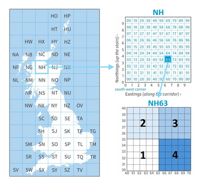
OS grid references are based on 100 km squares which are identified by letter-pairs as shown in the main diagram opposite i.e. NH.
The areas are the further broken down into 10 km by 10 km squares using 2 digits which precede the letters i.e. NH63 as shown in the top right hand diagram opposite.
As our squares are 5 km by 5 km we have broken this down further into quarters and used the number system shown opposite. Therefore, NH63 1 represents the 1st square in the bottom left hand corner and NH63 3 represents the 3rd square in the top right hand corner of the 10 km square.
For further information on ordnance survey grid references see Ordnance Survey | Great Britain's national mapping service